In September 2019, Rachel and I passed through the Sutjeska National Park in Bosnia and decided we wanted to go for a hike. We only had a single day, so we were looking for a 4-5 hour hike so that we could enjoy the beautiful nature of Bosnia.
We were extremely happy when we found an amazing hike to the gorgeous Trnovacko Lake. The hike was perfect, allowing us to park our car up in the mountains at the start of the track, and we enjoyed every moment in these beautiful mountains. The hike took us roughly 5 hours, with plenty of time to enjoy the beautiful mountains!
Since it was quite difficult to find information about this hike, I’ve written this post to make your life easier. If you want to go on an awesome day hike in the Sutjeska National Park, look no further. This is the complete guide to hiking to the Trnovacko Lake!
Contents
How to get to the start of the Trnovacko Lake hike
Since there was so little information available online about this hike, my girlfriend and I had the most trouble finding information about where to park our car. We read in various places that there was a car park at the start of the hike but also read conflicting stories about what the road would look like.
Some sites claimed that the car park was only accessible by 4×4 ATV’s, while others said that it was perfectly fine to reach with a small car.
We found the location of the car park in Google Maps (here’s a link to the exact location that you can navigate to) and decided to just go for it.
(if you go click that Google Maps link and go to “satellite view”, you can see the car park with a few parked cars there.)
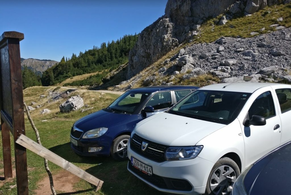
Did we have a 4×4? Nope! We had rented a Skoda Citigo on our Bosnia trip, which was the cheapest car that was available to us. Not exactly an all-terrain vehicle, eh? 😉
It was a bit of a bumpy ride, but nothing to worry about. The road up the mountains starts as a paved road, with some big patches, cracks, and holes in it. After a while, the road turns into a gravel road, which I actually found easier to drive, since the holes are less deep and more visible.
All in all, the car park at the end of the road is perfectly accessible, as long as you drive carefully. I would not worry about this at all.
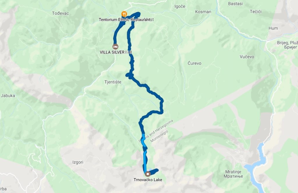
This is the GPS data that was tracked during the day that we went for the Trnovacko Lake hike. 🙂
Entrance to the Sutjeska National Park
It’s good to know that you’ll need to pay an entrance fee to the Sutjeska National Park.
When driving up the road to the car park, you’ll come across a barrier, with a guard that opens and closes this after you’ve paid. The entrance fee for the Sutjeska National Park is 5 KM, or about 2.5 Euros. After paying the fee, the guard smiled and opened the gate for us.
What to bring on your hike to the Trnovacko Lake hike
The hike to Trnovacko Lake is quite easy. The path is in good shape, and there are sufficient signs along the way so that you won’t get lost.
You won’t be needing a compass or climbing gear for this hike, that’s for sure! That is, unless you’re planning to climb Mt. Maglić. If that’s your plan, I’d suggest you find another guide! 🙂
My girlfriend and I brought the following:
- Water!
- Your passport (as you’ll be crossing the border to Montenegro).A healthy snack (we packed a couple of bananas).
- Sturdy shoes (some parts of the hike are gravelly, so you’ll need the extra grip).
- A backpack.
- Multiple layers of clothing.
- Camera.
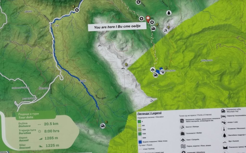
- It’s a good idea to take a picture of the map with your phone. This map is located at the car park and includes a route of the hike with the terrain for elevations.
Hiking to the Trnovacko Lake
As soon as you’ve got everything with you, it’s time to hit the road!
The hike starts off with a relatively flat path along the slope of a beautiful mountain valley. When you look to your right, you’ll look down into the valley which you’re slowly descending.
This part of the hike includes some gravelly sections, as you can see in the picture below.
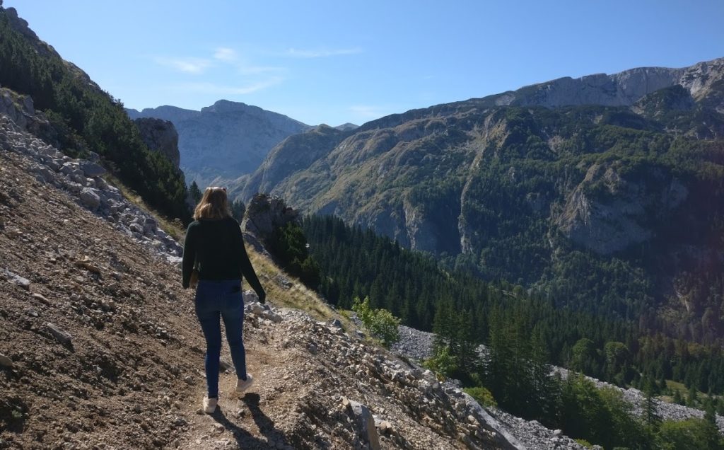
Just be careful and everything will be fine!
Entering Montenegro
After a kilometer or two, you’ll start to descend into the valley. At this point, you’ll officially enter Montenegro. No passport stamps are required! This was the easiest border crossing of our lives.
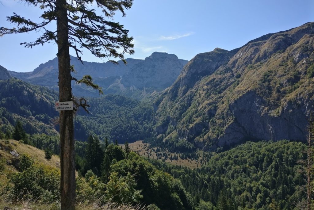
The path will continue down the valley, into the flat area which you see in the picture above. This part of the Trnovacko Lake hike is truly mesmerizing, especially since you’re slowly descending which is always nice.
Climbing up to the Trnovacko Lale
After passing the flat piece of land at the end of the valley, you’ll be faced with a small climb. This climb took us about 30 minutes, and it was over before we knew it. After this short climb, you’ll be rewarded with a view of the beautiful Trnovacko Lake!
Entrance fee to the Trnovacko Lake
When you get to the lake, you’ll see a wooden building, in which the “warden” of the area lives. This guy came out to greet us, and told us we had to pay another entrance fee since the actual Trnovacko Lake is in Montenegro and is maintained and governed by them, and not Bosnia!
He was a friendly guy and told us something about the area (in broken English) and happily told us to have a good day!
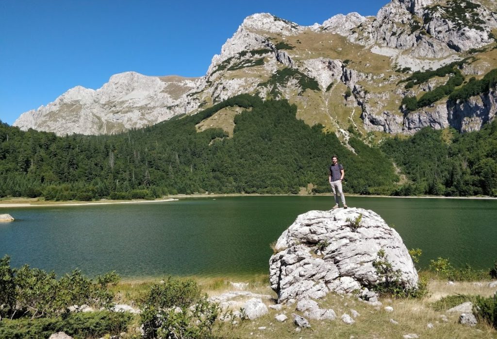
We walked around the lake for an hour or so, taking beautiful pictures of Mount Maglic and posing on some huge boulders. The weather was great, and we really took our time to enjoy this amazing part of the world.
At Trnovacko Lake, you’ll likely notice a couple of campers and tents. These people use the lake as their base camp for climbing the biggest mountain in the region: Mount Maglic. My girlfriend and I were quite jealous of these people, as we couldn’t stay at this wonderful location. We had to get back to our car in order to continue our trip through the Sutjeska National Park and the remainder of Bosnia and Herzegovina!
Wrapping up
I hope this post has convinced you to do this spectacular day hike. It was the highlight of our stay in Bosnia. We had a hard time collecting information about this hike, so I hope this post has helped clear things up for you.
If you have a question, leave it in the comments below and I’ll do my best to get back to you!
Sadly the road now is impassable unless with a 4×4. And the entrance fee is now €5. We got halfway up the track, got completely stuck, and had to reverse down. Wish we could’ve done this beautiful walk!
Ah, that’s a shame! Thanks for letting us know!
Edit: To all others reading this comment, we’ve received comments from readers that the road is still, in fact, accessible (as described in our article). No need for concerns, as far as I can tell!
Could you elaborate more? What exactly made it impassable?
Maybe you are taking about two different roads? Because I see two on the map. I’m thinking to go up there, but can’t decide now. I’m with a motorbike – so need to consider some stuff. 😀
We just did the hike a few days ago. The road was not a problem as long as you drive slowly. Then it is just a matter of patience. It took us one hour each way to drive the 17km of rough road. We had a rental Seat Ibiza and it was doable.
Thank you for this Nice guide!
Hi Hugo. Thank you for this review! This is literally the most comprehensive and informative guide to Trnovacko Lake! There aren’t really much English info about this place and regarding the question whether you can drive up to the hill, I heard so many contradicting answers. I was driving the cheapest rental car I could get too. But you’ll never know unless you try. I went in July 2022. I drove up and turned out it was not that difficult for a small car to climb up. There were only 2 – 3 times when I had to really slow down and carefully drive over the bumps. So yes you can still drive up. But it was a pity that you couldnt have a bird view of the lake if you took the standard route. You need to go for the more challenging route and climb around the mountain for that. Anyway, this review really helped me a lot. Thanks.
Thanks for your kind words! Really appreciated! 🙂
Thanks for the information!
Drove up there today in a rented peugot 206, no problems at all. Definitely no 4×4 necessary, most cars in the car park were normal cars, even a fiat punto got there.
That’s great to hear! Thanks for sharing!
May I kindly ask you how long does it take to hike from the car park to the lake and back?
If I remember correctly, it took us about 2-3 hours to get to the lake!